While the country’s attention shifted to Bagyong Basyang (international name: Penha) battering the Visayas and Mindanao on Friday, February 6, portions of the region were already flooded days before the storm made landfall.
A quiet but destructive weather system had already triggered flooding and landslides in Eastern Visayas, particularly in Leyte, earlier this week.
It is a recurring nightmare for the region – a weather pattern that brings torrential rains without the "typhoon" label.
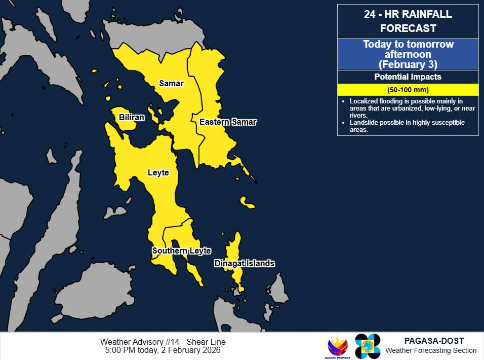
On Tuesday, February 3, residents in Tacloban City, Leyte and nearby towns like Palo woke up to floodwaters rising not because of a cyclone, but due to the shear line.
In its weather advisory issued that morning, the Philippine Atmospheric, Geophysical and Astronomical Services Administration (Pagasa) noted that the shear line brought moderate to heavy rains ranging from 50 to 100 millimeters (mm).
Local reports indicated that heavy rains triggered widespread flooding in Leyte, rendering roads impassable and forcing families to evacuate.
The state weather bureau said the impacts were likely worsened by "significant antecedent rainfall," meaning the ground was already saturated from previous rains before Tuesday’s downpour even began.
The culprit behind this pre-storm destruction is often misunderstood because it lacks the fancy name of a typhoon.
A shear line is essentially a convergence zone where two different air masses meet.
Imagine a collision on the highway: the cold, dry air from the Northeast Monsoon (Amihan) crashes into the warm, moist air from the Pacific Ocean (Easterlies). Because these two air masses have different temperatures and densities, they do not mix easily.
Instead, the warm air is forced to rise over the cold air. As it rises, it cools down and condenses, forming thick, heavy rain clouds.
Unlike a typhoon that moves across the map, a shear line can hover over a specific area for days, dumping continuous rain until the soil can no longer absorb the water.
This leads to flash floods and landslides, even when the sky appears relatively calm in neighboring provinces.
This is not the first time this year that the shear line has affected the region. Eastern Visayas and parts of Mindanao grappled with similar torrential rains throughout January, leaving the soil unstable.
When the ground is saturated, it reaches a landslide threshold – a point where even a moderate amount of rain can cause slopes to collapse.
Now, the situation has compounded. As of 5 am on February 6, Pagasa noted in an advisory that Tropical Cyclone Basyang is dumping greater than 200 mm of rain over Cebu, Bohol, and Surigao del Norte.
The advisory added that the shear line remains active, threatening to bring moderate to heavy rains to areas in Luzon like Quezon and Camarines Norte by the weekend.
The persistence of the shear line, now overlapping with Basyang, highlights a critical reality for disaster preparedness: a weather disturbance does not need a name to be deadly.
Stay prepared for typhoons and emergencies. Save lives through at app.lyfsaver.ph.